J
Reshaping collaborative modeling and decision-making for innovation, impact, and resilience

Fora.ai is Northeastern University’s collaborative whiteboard platform to bring teams together, anytime, anywhere.
How it Works
Build. Collaborate. Launch.

Define your priorities
Before designing draft plans, each participant will set their order of priorities within a concern profile.
Solution building
Facilitators and participants work together, collaboratively creating and adjusting a solution to their problem.

Run simulations
With the pieces in place, it’s time to view how the proposed solution performs with different priorities in mind.

Collaborate and change
Participants collaborate, co-design solutions, and test them against different priorities until they agree on one of them for implementation.
Enhance your teamwork
Our suite of collaboration tools helps your team be more productive than ever. See how they work below!
Create a project anywhere in the world
Easily create new projects on any place, any size, at the resolution of your choice.
Just name your new project, select the model to use (in this example, the L-GrID flooding model), and set a budget to work with for solution-building.
Then, enter a location anywhere in the world, set the resolution you need, and drag the cursor across the area you want to model.
Now you have a landscape to work on and simulate!
Edit the landscape
Modify the landscape you created.
Fora.ai assigns landscape data automatically (e.g., ground cover, elevation), but you might need to correct or change them.
Click in the changes and you’re ready!
Rank your priorities
Show how the impacts you’re modeling matter to you.
All participants have their unique “concern profile.”
Each user can set their priorities by dragging and dropping the model outputs (concerns) from highest to lowest (e.g. for flooding, this might include property damage, flooded streets, and runoff downstream).
You can also modify concern weights by entering their numbers and the ranking will adjust automatically.
The concern profiles are used to visualize the impacts of each solution by what people care about (see below under “compare simulation results…”).
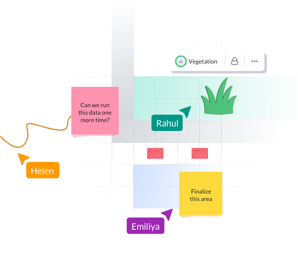
Create solutions together
Collaboratively add intervention tokens on your project map to create a solution you want to simulate.
Everyone in a team will meet in the collaborative map and work together to build solutions (in this example, green infrastructure to deal with flooding).
The sidebar on the left shows the different intervention tokens (e.g., green infrastructure types).
Click on the token type you want to place and then click on the map to add it there. Toggle data layers to inform your choices. If you made a mistake, you can delete it!
Continue creating a solution together until everyone is ready to try it out in a simulation.
Understand how each solution works
Explore the simulations
The video on the left shows how the solution works for this place (e.g., how flooding reduces flooding).
Impacts for each concern are summarized on the right relative to no intervention.
Make better decisions

Make informed decisions by comparing different solutions across metrics and concerns.
Each simulation will show how that solution works relative to a starting point (without any interventions).
Score bars show how each solution performs for each user.
As people learn together, solutions get better across metrics (bars get longer) and for everyone (bars get more even across teammates).
Don’t start from scratch
We’ve streamlined common processes for easier collaboration so you can focus on innovating solutions.

All projects in one place
Create, view, update, and complete

Organize draft plans
View a change log to keep up to date

Invite, collaborate and share
Easily build your project team

Map templates
Save time by starting from existing maps
Online terrain editor
Adjust layers and elevation levels

Run simulations and repeat
See live results and compare